SCAR Antarctic Digital Database (ADD) Previous Datasets
- Edition
- 15
- Published
Previous versions of Scientific Committee on Antarctic Research (SCAR) Antarctic Digital Database (ADD) datasets.
See the main ADD collection for more information.

A medium resolution seamask for regions south of 60°S, comprised of a roundel polygon with all land and ice shelves erased.
Antarctic coastline south of 60°S, consisting of land, ice shelf, ice tongue, and rumple features as polygons.
Generalised Antarctic coastline south of 60°S, consisting of land, ice shelf, ice tongue and rumple features as polygons.
Generalised Antarctic coastline south of 60°S, consisting of ice coastline, rock coastline, grounding line, ice shelf and front, ice rumple, and 'rock against ice shelf' line features.
Antarctic coastline south of 60°S, consisting of ice coastline, rock coastline, grounding line, ice shelf and front, ice rumple, and 'rock against ice shelf' line features.
A high resolution seamask for regions south of 60°S, comprised of a roundel polygon with all land and ice shelves erased.
Generalised Antarctic coastline south of 60°S, consisting of land, ice shelf, ice tongue and rumple features as polygons.
A high resolution seamask for regions south of 60°S, comprised of a roundel polygon with all land and ice shelves erased.
Generalised Antarctic coastline south of 60°S, consisting of ice coastline, rock coastline, grounding line, ice shelf and front, ice rumple, and 'rock against ice shelf' line features.
Antarctic coastline south of 60°S, consisting of ice coastline, rock coastline, grounding line, ice shelf and front, ice rumple, and 'rock against ice shelf' line features.
Antarctic coastline south of 60°S, consisting of land, ice shelf, ice tongue and rumple features as polygons.
Generalised rock outcrop in Antarctica derived from maps and remote sensing data from 1960-2023. Primarily compiled in 1993 with uncertain quality and accuracy.
Rock outcrop in Antarctica derived from maps and remote sensing data from 1960-2023. Primarily compiled in 1993 with uncertain quality and accuracy.
A medium resolution seamask for regions south of 60°S, comprised of a roundel polygon with all land and ice shelves erased.
Generalised Antarctic coastline south of 60°S, consisting of land, ice shelf, ice tongue and rumple features as polygons.
Antarctic coastline south of 60°S, consisting of land, ice shelf, ice tongue and rumple features as polygons.
Generalised surface lake features in Antarctica derived from maps and remote sensing data. Significantly incomplete.
Moraine features in Antarctica derived from maps and remote sensing data. Incomplete.
Rock outcrop in Antarctica derived from maps and remote sensing data from 1960-2023. Primarily compiled in 1993 with uncertain quality and accuracy.
Generalised rock outcrop in Antarctica derived from maps and remote sensing data from 1960-2023. Primarily compiled in 1993 with uncertain quality and accuracy.
Antarctic coastline south of 60°S, consisting of ice coastline, rock coastline, grounding line, ice shelf and front, ice rumple, and 'rock against ice shelf' line features.
Surface lake features in Antarctica derived from maps and remote sensing data. Significantly incomplete.
Generalised Antarctic coastline south of 60°S, consisting of ice coastline, rock coastline, grounding line, ice shelf and front, ice rumple, and 'rock against ice shelf' line features.
A high resolution seamask for regions south of 60°S, comprised of a roundel polygon with all land and ice shelves erased.
A medium resolution seamask for regions south of 60°S, comprised of a roundel polygon with all land and ice shelves erased.
Generalised moraine features in Antarctica derived from maps and remote sensing data. Incomplete.
Antarctic coastline south of 60°S, consisting of ice coastline, rock coastline, grounding line, ice shelf and front, ice rumple, and 'rock against ice shelf' line features.
Generalised Antarctic coastline south of 60°S, consisting of ice coastline, rock coastline, grounding line, ice shelf and front, ice rumple, and 'rock against ice shelf' line features.
Antarctic coastline south of 60°S, consisting of land, ice shelf, ice tongue and rumple features as polygons.
Generalised Antarctic coastline south of 60°S, consisting of land, ice shelf, ice tongue and rumple features as polygons.
A high resolution seamask for regions south of 60°S, comprised of a roundel polygon with all land and ice shelves erased.
A medium resolution seamask for regions south of 60°S, comprised of a roundel polygon with all land and ice shelves erased.
Continuous 1000m interval contours for land south of 60°S, generated from high resolution contours derived from maps and remote sensing data. Contains inconsistencies and known errors.
Continuous, smoothed 500m interval contours for land south of 60°S, generated from REMA v1.1 and other sources.
Continuous 100m interval contours for land south of 60°S, generated from REMA v1.1 and other sources.
Antarctic coastline south of 60°S, consisting of ice coastline, rock coastline, grounding line, ice shelf and front, ice rumple, and 'rock against ice shelf' line features.
Generalised rock outcrop in Antarctica derived from maps and remote sensing data from 1960-2023. Primarily compiled in 1993 with uncertain quality and accuracy.
Generalised Antarctic coastline south of 60°S, consisting of land, ice shelf, ice tongue and rumple features as polygons.
A medium resolution seamask for regions south of 60°S, comprised of a roundel polygon with all land and ice shelves erased.
Generalised Antarctic coastline south of 60°S, consisting of ice coastline, rock coastline, grounding line, ice shelf and front, ice rumple, and 'rock against ice shelf' line features.
Rock outcrop in Antarctica derived from maps and remote sensing data from 1960-2023. Primarily compiled in 1993 with uncertain quality and accuracy.
Rock outcrop in Antarctica, automatically extracted from Landsat 8 imagery.
Antarctic coastline south of 60°S, consisting of land, ice shelf, ice tongue and rumple features as polygons.
Surface lake features in Antarctica derived from maps and remote sensing data. Significantly incomplete.
A high resolution seamask for regions south of 60°S, comprised of a roundel polygon with all land and ice shelves erased.
Generalised surface lake features in Antarctica derived from maps and remote sensing data. Significantly incomplete.
Moraine features in Antarctica derived from maps and remote sensing data. Incomplete.
Stream features in Antarctica mainly covering Byers Peninsula, Deception Island, James Ross and Seymour islands, Fossil Bluff and parts of the Transantarctic Mountains. Significantly incomplete.
Generalised moraine features in Antarctica derived from maps and remote sensing data. Incomplete.
High resolution (scale0) lines of the Antarctic coastline. This dataset was originally published in tiled coverage format. Data has since been converted and merged to a single dataset and exported to shapefile and GeoPackage formats. The data are published as they stood at the time of their first publication.
High resolution (scale0) polygons of the Antarctic coastline. This dataset was originally published in tiled coverage format. Data has since been converted and merged to a single dataset and exported to shapefile and GeoPackage formats. The data are published as they stood at the time of their first publication.
Bounding Coordinates
- South-West Corner (min x/y)
- South: -90.0, West: -180.0
- North-East Corner (max x/y)
- North: -60.0, East: 180.0
Related collections
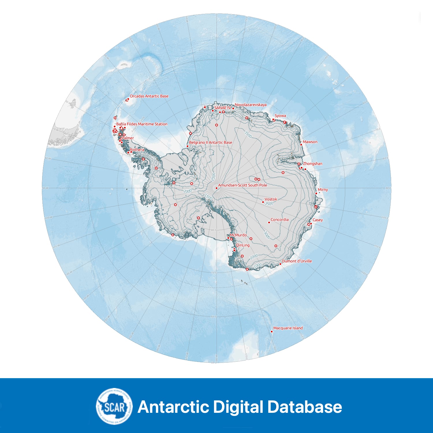
Seamless topographic datasets of Antarctica south of 60°S. Compiled from the best available geographic information on behalf of the Scientific Committee on Antarctic Research (SCAR).
Item Information
- Item ID
- 8ff8240d-dcfa-4906-ad3b-507929842012
- Item Type
- COLLECTION
- Item edition
- 15
- Item Created
- Item Published
- Item Updated
- Item Released
- Item Status
- Item is complete and recommended for general use
- Item Update Frequency
- Item may be updated if needed
Metadata Information
- Last updated
- Metadata Standard
- ISO 19115-2 Geographic Information - Metadata - Part 2: Extensions for Imagery and Gridded Data
- Metadata Standard Version
- ISO 19115-2:2009(E)
- Metadata Profiles
- British Antarctic Survey (BAS) Mapping and Geographic Information Centre (MAGIC) Discovery Metadata Profile (v2) External link, opens in a new window.
- British Antarctic Survey (BAS) Mapping and Geographic Information Centre (MAGIC) Administration Metadata Profile (v1) External link, opens in a new window.
- Metadata Licence
- Creative Commons Attribution-NoDerivatives 4.0 International External link, opens in a new window.
- Metadata Links
- Item page build time
Alternative contact methods
By post
British Antarctic SurveyHigh Cross
Madingley Road
Cambridge
Cambridgeshire
CB3 0ET
United Kingdom
By phone
By email
Privacy Notice
If you contact us, your personal information will be retained for up to three years and then deleted. It will only be used to contact you regarding your enquiry. If this item relates to an external organisation, we may share an anonymised version of your enquiry with them to help answer your query.
We use Cloudflare Turnstile, a third-party service, to protect against spam enquires.
See our privacy policy for more information.